Another front
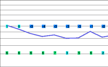
A weak ridge of high pressure over the South Coast will give generally dry conditions to the region this evening. A frontal system approaching Vancouver Island will spread snow. For Friday this system will result in rain at lower elevations and snow at higher elevations and amounts are expected to be quite significant.
On Saturday another impulse from the Pacific will result in showers or flurries. Meanwhile the airmass will remain unstable on Sunday and scattered precipitation is expected and a sunny break cannot be ruled out. By Monday yet another system will advance bringing some precipitation to the area by evening. Latest indications suggest the most significant precipitation from this system will hold off until Monday night.
Tonight.. Periods of snow developing overnight. Areas of fog.
Snowfall amount 2 cm.
Alpine low minus 5.
Freezing level lowering to valley bottom.
Mountain top winds southeast 30 gusting to 50 km/h.
Friday.. Periods of snow. Areas of fog.
Snowfall amount 10 to 20 cm.
Alpine high minus 1.
Freezing level rising to 1500 metres.
Mountain top winds southeast 60 gusting 80 km/h.
Saturday.. Cloudy with flurries.
Snowfall amount trace to 2 cm.
Freezing level falling to 1100 metres.
Sunday.. Cloudy with sunny breaks. 60 percent chance of flurries.
Freezing level rising to 1300 metres.
Monday.. Cloudy with a few flurries.
Snowfall amount trace to 2 cm.
Freezing level near 1300 metres.


