Sun
A ridge of high pressure will continue to build over the South Coast in the next couple of days bringing drier and warmer conditions.
The ridge of high pressure will remain anchored over BC through the weekend giving dry and warm conditions.
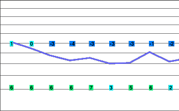
Today..Clearing this morning. Fog patches dissipating this morning.
Alpine high near minus 1.
Freezing level rising to 1400 metres this afternoon.
Mountain top winds light and variable.
Tonight..Clear.
Alpine low minus 7.
Freezing level lowering to valley bottom.
Mountain top winds light and variable.
Thursday..Sunny.
Alpine high minus 1.
Freezing level rising to 1400 metres in the afternoon.
Mountain top winds light and variable.
Friday.. Sunny.
Freezing level valley bottom rising to 2200 metres in the afternoon.
Saturday.. Sunny.
Freezing level valley bottom rising to 2200 metres in the afternoon.
Sunday.. Sunny.
Freezing level valley bottom rising to 2200 metres in the afternoon.


