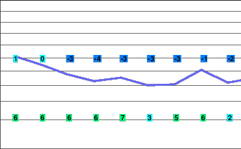
A series of Pacific disturbances
A ridge of high pressure over the South Coast will weaken this morning allowing a Pacific frontal system to approach the region this afternoon. This system will bring precipitation and stronger winds through Wednesday.
A series of Pacific disturbances will move across the South Coast through Saturday bringing precipitation.
Today.. Mostly cloudy. Periods of light snow beginning late this afternoon.
Snowfall amount trace.
Alpine temperature falling to minus 4 this afternoon.
Freezing level rising to near 1300 metres this afternoon.
Mountain top winds light becoming southeast 30 km/h this afternoon.
Tonight.. Periods of light snow.
Snowfall amount 2 to 4 cm.
Alpine temperature steady near minus 4.
Freezing level lowering to valley bottom.
Mountain top winds southeast 40 gusting to 70 km/h becoming southwest 30 gusting to 50 km/h overnight.
Wednesday.. Periods of snow.
Snowfall amount 5 to 10 cm.
Alpine temperature steady near minus 4.
Freezing level rising to 1200 metres in the afternoon.
Mountain top winds southwest 30 gusting to 50 km/h.
Thursday.. Snow tapering to flurries.
Snowfall amount 10 cm.
Freezing level near 1200 metres.
Friday.. Periods of snow.
Snowfall amount 10 to 20 cm.
Freezing level near 1500 metres.
Saturday.. Cloudy with 40 percent chance of flurries.
Freezing level near 1400 metres.


