Snow this morning
A frontal system will move east of the region this morning ending the precipitation. Drier and cooler air will move into the area behind this system later today as a ridge of high pressure builds. Dry conditions are expected on Wednesday as the ridge becomes established in the BC Interior.
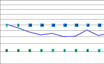
5 Day Trend..The ridge of high pressure will maintain through Saturday giving dry conditions.
Today..Snow tapering to a few flurries late this morning then cloudy.
Snowfall amount 5 to 10 cm.
Alpine high near zero.
Freezing level rising to 1400 metres.
Mountain top winds southwesterly 20 gusting 40 km/h.
Tonight.. Partly cloudy.
Alpine low minus 7.
Freezing level lowering to valley bottom.
Mountain top winds light.
Wednesday..Mainly cloudy then becoming sunny near noon.
Alpine high near zero.
Freezing level rising to 1300 metres in the afternoon.
Mountain top winds light.
Thursday.. Sunny.
Freezing level 1800 metres except below freezing layer near the valley bottom in the morning.
Friday.. Sunny.
Freezing level 1800 metres except below freezing layer near the valley bottom in the morning.
Saturday.. Sunny.
Freezing level 1800 metres except below freezing layer near the valley bottom in the morning.


