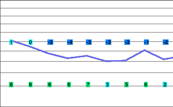
Clouds then winter again
Lingering precipitation is expected this morning and then sunny breaks this afternoon as a ridge of high pressure builds. A warm front is forecast to approach on Saturday bringing some light precipitation.
The cold front will cross the region on Sunday.
Another frontal system is expected to bring more precipitation and windy conditions on Monday. Cool and showery conditions will follow for Tuesday behind the front.
Today..Flurries ending this morning then afternoon sunny periods.
Alpine high near zero.
Snowfall accumulation slight.
Freezing level rising to 1800 metres this afternoon.
Mountaintop winds light.
Tonight..Becoming cloudy in the evening. Light snow beginning overnight.
Snowfall accumulation slight.
Alpine low minus 4.
Freezing level lowering to near valley bottom.
Mountaintop winds southwest 20 km/h.
Saturday..Periods of light snow.
Snowfall accumulation 2 to 4 cm.
Alpine high minus 1.
Freezing level rising to 1500 metres.
Mountaintop winds southerly 30 km/h.
Sunday..Periods of snow ending.
Snowfall accumulation 10 to 20 cm.
Freezing level 1500 metres.
Monday..Snow.
Snowfall accumulation 15 to 25 cm.
Freezing level 1000 metres.
Tuesday..Periods of snow.
Snowfall accumulation 10 cm.
Freezing level 800 metres.


