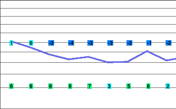
A nice forecast
A ridge of high pressure over the South Coast will give dry conditions through tonight. A low pressure system is forecast to approach the coast on Friday spreading flurries to the alpine areas late in the day.
Today..A mix of sun and cloud.
Alpine high near minus 1.
Freezing level rising to 1600 metres this afternoon.
Mountain top winds becoming southwest 20 km/h this afternoon.
Tonight..Clear.
Alpine low minus 4.
Freezing level lowering to valley bottom.
Mountain top winds light and variable.
Friday..Mainly sunny. Increasing cloudiness in the afternoon with a few flurries developing late in the day.
Snowfall amount 2 to 4 cm.
Alpine high minus 2.
Freezing level rising to 1600 metres in the afternoon.
Mountain top winds becoming southeast 30 km/h in the afternoon.
5 Day Trend..The low pressure system will move north of the region on Saturday allowing the ridge of high pressure to rebuild over the South Coast. This ridge will maintain generally dry conditions through Monday.
Saturday..Snow tapering to flurries in the morning then a mix of sun and cloud.
Snowfall amount 5 cm.
Freezing level 1300 metres.
Sunday..A mix of sun and cloud.
Freezing level 1600 metres.
Monday..A mix of sun and cloud.
Freezing level 2400 metres.


